I spent a good portion of the summer section-hiking the PCT through (thru?) Washington, from Panther Creek Campground, a bit north of Bridge of the Gods, to the North Cascades Highway. With side trips and wandering, the whole thing came out to just shy of 500 miles, and took 26 days.
It’s taken me a while to start writing about it here because life kept getting in the way, and I guess also because it’s still a lot to digest. It’s been months, but the whole thing just recently started making sense to me.
The next few dozen posts will be daily journals from the trip, and I’ll post links here as they’re finished.
Preliminary

Section H: Bridge of the Gods to White Pass (PCT 2144.2 – 2292.4, 148.2 miles)
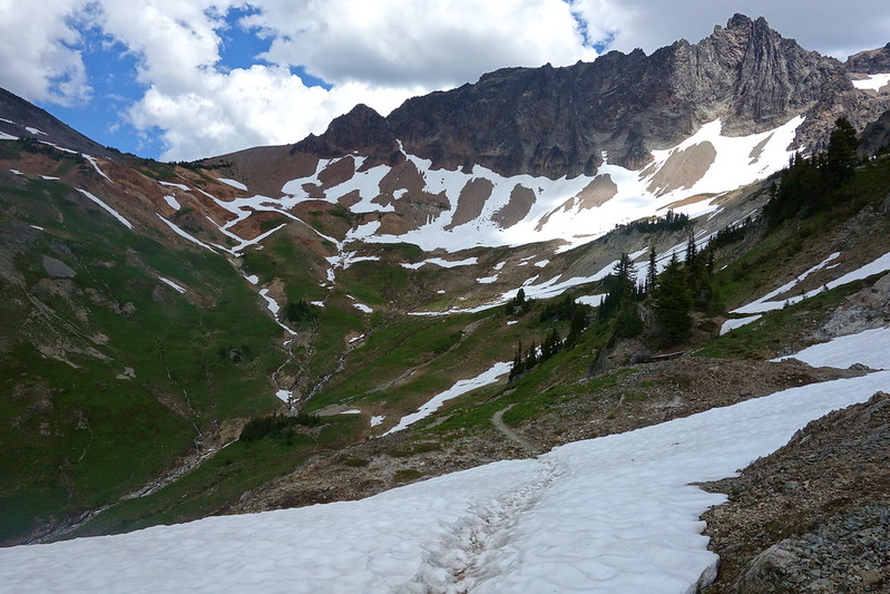
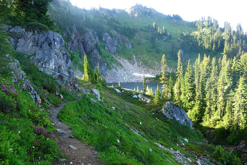
Section H is the longest section in Washington, and the most varied. The first fifty or so miles pass through nondescript second and third growth forest, through clear cuts and along old roads. But then there’s a series of successively more serene wildernesses: Indian Heaven, full of craggy peaks, subalpine ponds, and pesky mosquitoes; Mt. Adams, where the trail cuts a nearly flat path along the west side, past enumerable lava flows, snowmelt streams, flowered meadows, and endless views; and finally, Goat Rocks, which is rightly regarded as perhaps the prettiest section of trail in Washington, full of snowy basins, bright meadows, and rocky ridges stretching to infinity.
- Day 1 (July 17): Panther Creek to Gifford Peak (PCT 2179.5 – 2202, 22.5 miles)
- Day 2 (July 18): Gifford Peak to Dry Meadows (PCT 2202 – 2224.5, 22.5 miles)
- Day 3 (July 19): Dry Meadows to Killen Creek Falls (PCT 2224.5 – 2241.8, 17.3 miles)
- Day 4 (July 20): Killen Creek Falls to Short Trail Camp (PCT 2241.8 – 2262.1, 20.3 miles)
- Day 5 (July 21): Short Trail Camp to Elk Pass (PCT 2262.1 – 2277.4, 15.3 miles)
- Days 6 + 7 (July 22 +23): Elk Pass to White Pass (PCT 2277.4 – 2292.4, 15.5 miles, including roadwalk to White Pass)
Section I: White Pass to Snoqualmie Pass (PCT 2292.4 – 2390.6, 98.2 miles)
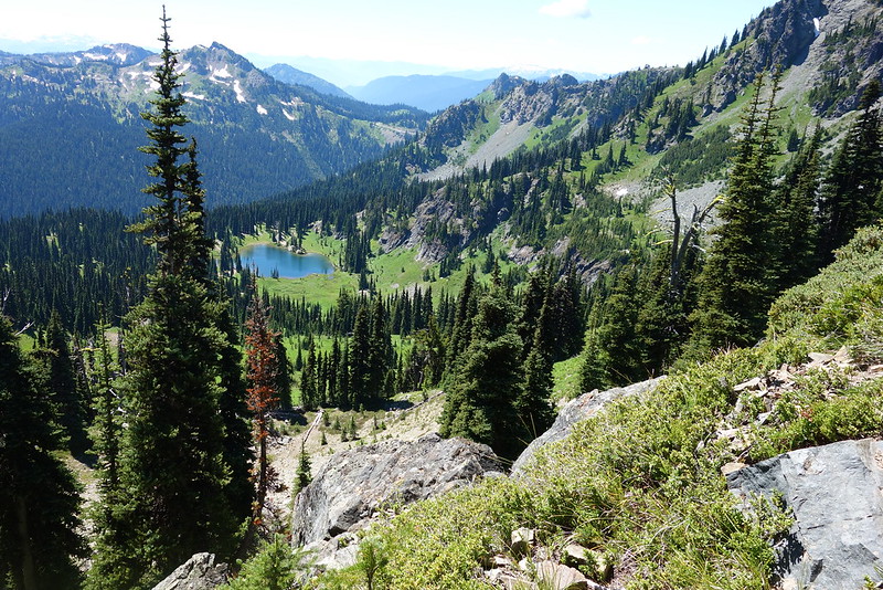
Section I has a split personality. For the first fifty miles, it passes through wonderfully varied wilderness: subalpine lakes through the William O. Douglas Wilderness; steep, rocky ridges on the eastern tip of Mt. Rainier National Park and southern half of the Norse Peak Wilderness; and deep, old forest as it descends through the northern half of Norse Peak. But then, between the Norse Peak Wilderness boundary and Snoqualmie Pass, it enters a checkerboard of public and private land, all touched by a long history of logging: clear cut scars to the horizon; charred trees from a fire started by loggers; dozens of hastily built roads; and water made scarce by impoverished soil.
- Day 8 (July 24): White Pass to Dewey Lake (PCT 2292.4 – 2317.9, 25.5 miles)
- Day 9 (July 25): Dewey Lake to Arch Rock Spring (PCT 2317.9 – 2339.1, 21.2 miles)
- Day 10 (July 26): Arch Rock Spring to Tacoma Pass (PCT 2339.1 – 2361.6, 22.5 miles)
- Day 11 (July 27): Tacoma Pass to Mirror Lake (PCT 2361.6 – 2382.1, 20.5 miles)
- Day 12 (July 28): Mirror Lake to Snoqualmie Pass (PCT 2382.1 – 2390.7, 8.6 miles)
Section J: Snoqualmie Pass / I90 to Stevens Pass / US2 (2390.6 – 2461.6, 71 miles)
Section J is just magnificent. It spends nearly its entire 70 miles in the Alpine Lakes Wilderness, traversing endless ridges, meeting deep blue pools and rushing rivers, and just generally being more consistently pleasant than I thought a trail of this length capable of being. Even in foul weather—I walked out in a storm—there are still the nearby pleasures of deep woods and complex granite walls. Most full thru-hikers do the whole thing in two or three nights. I took four, including a couple halfdays, but could easily have stayed for twice that, exploring the many, many possible side trips. If one were looking for an easily manageable section to hike, this would be a very good place to start.
- Day 13 (July 29): Snoqualmie Pass to Spectacle Lake (PCT 2390.7 – 2407.8, 17.6 miles)
- Day 14 (July 30): Spectacle Lake to Waptus River Crossing (PCT 2407.8 – 2425.3, 18 miles)
- Day 15 (July 31): Waptus River Crossing to Peggy’s Pond and Above (PCT 2425.3 – 2435, 13.7 miles)
- Day 16 (Aug. 1): Peggy’s Pond to Mig Lake (PCT 2435 – 2454.2, 20.2 miles)
- Day 17 (Aug. 2): Mig Lake to Lake Janus (PCT 2454.2 – 2471.4, 17.2 miles)
Section K: Stevens Pass / US2 to Rainy Pass / SR20 (2461.6 – 2588.9, 127.3 miles)
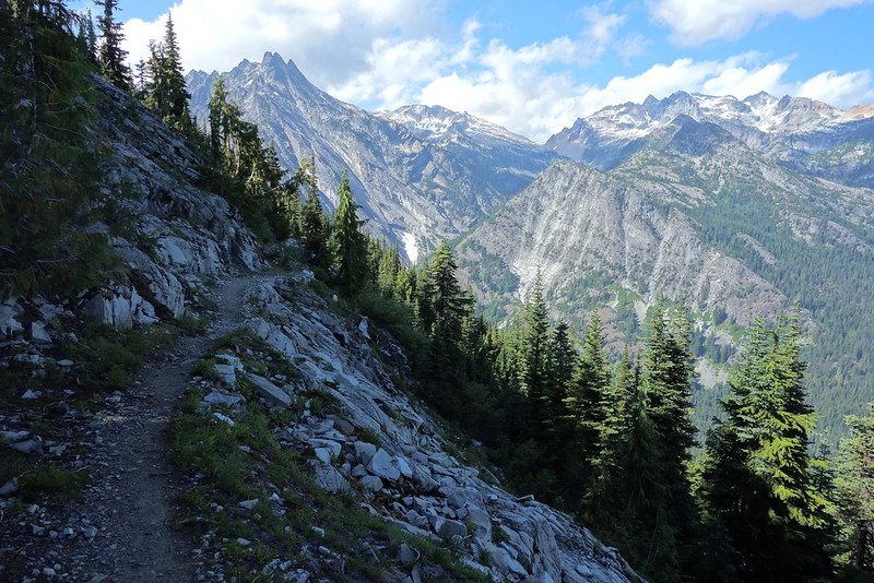
Before starting this section, northern Washington had always been sort of mythic to me: I’d driven through the North Cascades, and maybe been to Lake Chelan when I was a kid, but never spent any concerted time up there beside that. Holy hell! It’s… it’s just difficult to describe. I don’t think I’ve seen anything like it, save perhaps the Sierras, but even there, it’s often just granite. (Okay, “just,” but you know what I mean.) In northern Washington, it’s granite and glaciers and deep deep river valleys and sun and storms always ready to cross some distant pass and take over the skies. It’s wild in a way different, and deeper, than any other place I’ve ever been. It’s also, unless you’re thru-hiking, kind of a pain to get to. Some of these areas are twenty or thirty miles from the nearest trailhead. It made passing through sort of tragic–when am I ever going to get here again?–but it also meant that I spent most days and nights alone, surrounded by mountains and glaciers and trees and sky.
- Day 18 (Aug. 3): Lake Janus to Lake Sally Ann (PCT 2471.4 – 2491, 19.6 miles)
- Day 19 (Aug. 4): Lake Sally Ann to Glacier Creek (PCT 2491 – 2512, 21 miles)
- Day 20 (Aug. 5): Glacier Creek to East Fork Milk Creek (PCT 2512 – 2529 (18 miles)
- Day 21 (Aug. 6): East Fork Milk Creek to Cloudy Pass Junction (PCT 2529 – 2550.1, 21.1 miles)
- Day 22 (Aug. 7): Cloudy Pass Junction to Pass Creek (PCT 2550.1 – 2564.3, 14.2 miles)
- Day 23 (Aug. 8): Pass Creek to High Bridge Ranger Station / Stehekin (PCT 2564.3 – 2569.4, 5.1 miles)
- Day 24 (Aug. 9): Stehekin / High Bridge Ranger Station to Park Creek / Two Mile Camp (North Cascades alternate, 10.1 miles)
- Day 25 (Aug. 10): Park Creek / Two Mile Camp to Thunder Creek / Junction Camp (North Cascades alternate, 14.8 miles)
- Day 26 (Aug. 11): Thunder Creek / Junction Camp to Diablo Lake (North Cascades alternate, 9.9 miles)
Afterward